
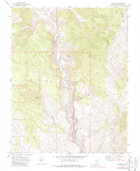
1969 Map of Elgin NE
USGS Topo · Published 1973About this map
Meadow Valley Wash carves through the center of this Lincoln County landscape, serving as the primary corridor for the Union Pacific railroad line. This late 1960s survey documents a high-desert environment defined by the steep elevation of the Clover Mountains and the dramatic relief of Rainbow Canyon. Small rail-oriented settlements like Stine and Boyd are positioned along the tracks, providing evidence of the essential transport infrastructure required to navigate these mountain passes. Evidence of mineral exploration appears with noted mines northeast of Boyd, while various tributary drainages such as Willow Creek, Acklin Canyon, and Rock Springs Canyon feed into the central wash. The map also records the Sawmill Trail winding through the eastern heights, reflecting the local history of logging or grazing access within the canyon systems.
Find a feature on this map
13 named features on this map. Tap any name to fly to it.
Don’t see what you’re looking for? This feature index may not catch every label — zoom into the map to look around manually.
Map Details
Editions of this 1969 Elgin NE Map
2 editions found
Other maps of this area

1885 · Pioche
USGS Topo · 1:250,000

1886 · Pioche
USGS Topo · 1:250,000

1954 · Caliente
USGS Topo · 1:250,000

1959 · Caliente
USGS Topo · 1:250,000

1969 · Elgin
USGS Topo · 1:24,000

1969 · Slidy Mountain
USGS Topo · 1:24,000

1969 · Elgin SW
USGS Topo · 1:24,000
1970 · Caliente
USGS Topo · 1:24,000
1970 · Chokecherry Mtn.
USGS Topo · 1:24,000
1972 · Eccles
USGS Topo · 1:24,000