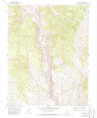
1969 Map of Elgin NE
USGS Topo · Published 1986About this map
Meadow Valley Wash carves a deep north-south corridor through this portion of Lincoln County, dictating the primary route for the Union Pacific railroad. This 1969 field-checked survey highlights the isolated nature of the terrain, where development is largely restricted to the valley floor. Small outposts like Stine and Boyd serve as points of interest along the tracks, likely functioning as railroad sidings or remote stations in this high-desert landscape.
Find a feature on this map
12 named features on this map. Tap any name to fly to it.
Don’t see what you’re looking for? This feature index may not catch every label — zoom into the map to look around manually.
Map Details
Editions of this 1969 Elgin NE Map
2 editions found
Other maps of this area

1885 · Pioche
USGS Topo · 1:250,000

1886 · Pioche
USGS Topo · 1:250,000

1954 · Caliente
USGS Topo · 1:250,000

1959 · Caliente
USGS Topo · 1:250,000

1969 · Elgin
USGS Topo · 1:24,000

1969 · Elgin NE
USGS Topo · 1:24,000

1969 · Slidy Mountain
USGS Topo · 1:24,000

1969 · Elgin SW
USGS Topo · 1:24,000
1970 · Caliente
USGS Topo · 1:24,000
1970 · Chokecherry Mtn.
USGS Topo · 1:24,000