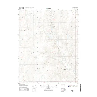
2015 Map of Elgin NE
USGS Topo · Published 2015About this map
Middle Caney Creek and its many tributaries carve a dendritic pattern through this corner of Chautauqua County, defining the rural character of the southern Kansas landscape. The settlement of Rogers sits near the confluence of Rock Cr and the main creek, where the local terrain features Butcher Falls. For genealogists, the map identifies several distinct burial sites including Denick Cem, Rogers Cem, and Spring Creek Cem, which often mark the centers of early community life in this ranching country.
Find a feature on this map
32 named features on this map. Tap any name to fly to it.
Don’t see what you’re looking for? This feature index may not catch every label — zoom into the map to look around manually.
Map Details
Editions of this 2015 Elgin NE Map
This is the sole edition of this map. No revisions or reprints were ever made.
Other maps of this area

1885 · Sedan
USGS Topo · 1:125,000

1889 · Sedan
USGS Topo · 1:125,000

1955 · Wichita
USGS Topo · 1:250,000

1958 · Wichita
USGS Topo · 1:250,000

1962 · Moline
USGS Topo · 1:24,000
1962 · Elk Falls
USGS Topo · 1:24,000

1962 · Sedan
USGS Topo · 1:24,000
1962 · Cedar Vale East
USGS Topo · 1:24,000

1962 · Elgin NE
USGS Topo · 1:24,000
1962 · Elgin
USGS Topo · 1:24,000