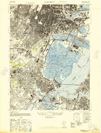
1947 Map of Elizabeth
USGS Topo · Published 1947About this map
Newark City Hall and the Essex County Hall of Records anchor a dense urban landscape on the eve of the post-war industrial boom. This 1947 revision, based on 1941 aerial photography, documents the intricate rail and maritime infrastructure of Elizabeth and Newark before significant suburban expansion. The transition from the massive Port of Newark and Newark Airport to the residential streets of Irvington and Hillside reveals a region defined by its transit hubs. Significant landmarks such as Seton Hall College and numerous religious grounds like Holy Sepulchre Cem and Rosehill Cem provide essential data for genealogists. The map also traces the vital connections of the Pulaski Skyway and Goethals Bridge, illustrating the complex geography where the Passaic River and Newark Bay meet the industrial shoreline of Elizabethport and Port Richmond.
Find a feature on this map
68 named features on this map. Tap any name to fly to it.
Don’t see what you’re looking for? This feature index may not catch every label — zoom into the map to look around manually.
Map Details
Editions of this 1947 Elizabeth Map
2 editions found
Other maps of this area

1888 · Plainfield
USGS Topo · 1:62,500

1888 · Morristown
USGS Topo · 1:62,500

1888 · Paterson
USGS Topo · 1:62,500

1892 · Paterson
USGS Topo · 1:62,500

1893 · Plainfield
USGS Topo · 1:62,500

1894 · Morristown
USGS Topo · 1:62,500

1898 · Morristown
USGS Topo · 1:62,500

1898 · Plainfield
USGS Topo · 1:62,500

1898 · Staten Island
USGS Topo · 1:62,500

1898 · Paterson
USGS Topo · 1:62,500