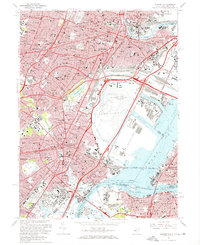
1967 Map of Elizabeth
USGS Topo · Published 1969About this map
The industrial and transportation heart of Northern New Jersey is displayed in detail during the late 1960s, a period of massive infrastructure growth. The New Jersey Turnpike and Garden State Parkway weave through a densely settled landscape where the legacy of rail and maritime commerce remains prominent. Massive shipping facilities at Port Newark and the Central Railroad of New Jersey Terminal border the waters of Newark Bay, while the Newark Airport is shown in a phase of expansion. Inland, the map documents the established neighborhoods of Elizabeth, Newark, and Irvington, interspersed with large green spaces like Weequahic Park and significant institutions such as Seton Hall Univ. For genealogists, the map is a vital resource for locating specific urban landmarks, including numerous cemeteries like Evergreen Cemetery and local parish churches like Sacred Heart Ch.
Find a feature on this map
77 named features on this map. Tap any name to fly to it.
Don’t see what you’re looking for? This feature index may not catch every label — zoom into the map to look around manually.
Map Details
Editions of this 1967 Elizabeth Map
Other maps of this area

1888 · Plainfield
USGS Topo · 1:62,500

1888 · Morristown
USGS Topo · 1:62,500

1888 · Paterson
USGS Topo · 1:62,500

1892 · Paterson
USGS Topo · 1:62,500

1893 · Plainfield
USGS Topo · 1:62,500

1894 · Morristown
USGS Topo · 1:62,500

1898 · Morristown
USGS Topo · 1:62,500

1898 · Plainfield
USGS Topo · 1:62,500

1898 · Staten Island
USGS Topo · 1:62,500

1898 · Paterson
USGS Topo · 1:62,500