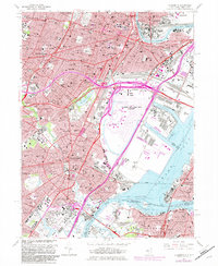
1967 Map of Elizabeth
USGS Topo · Published 1982About this map
Newark and Elizabeth anchor this industrial and transport landscape in the late 1960s, a period of massive infrastructure and urban density. The Newark International Airport and the complex interchange of the New Jersey Turnpike dominate the center, illustrating the post-war shift toward air and highway travel. Despite this modernization, the area remains a heavy rail hub with the Central RR of New Jersey and Pennsylvania Railroad serving the Oak Island Yards and waterfront terminals. Education and civic life are prominent through established institutions like Seton Hall Univ and Rutgers Univ (Newark Campus). For genealogists, the map is particularly valuable for its detailed marking of sprawling burial grounds, including the massive Evergreen Cemetery and Rose Hill Cemetery, alongside numerous local parish churches such as St Marys Ch and St Johns Sch Ch.
Find a feature on this map
103 named features on this map. Tap any name to fly to it.
Don’t see what you’re looking for? This feature index may not catch every label — zoom into the map to look around manually.
Map Details
Editions of this 1967 Elizabeth Map
Other maps of this area

1888 · Plainfield
USGS Topo · 1:62,500

1888 · Morristown
USGS Topo · 1:62,500

1888 · Paterson
USGS Topo · 1:62,500

1892 · Paterson
USGS Topo · 1:62,500

1893 · Plainfield
USGS Topo · 1:62,500

1894 · Morristown
USGS Topo · 1:62,500

1898 · Morristown
USGS Topo · 1:62,500

1898 · Plainfield
USGS Topo · 1:62,500

1898 · Staten Island
USGS Topo · 1:62,500

1898 · Paterson
USGS Topo · 1:62,500