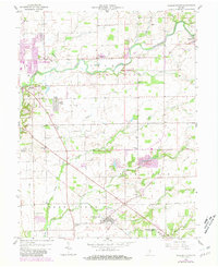
1958 Map of Elizabethtown
USGS Topo · Published 1981About this map
Columbus serves as the western anchor of this survey, which captures the Bartholomew County landscape through decades of mid-century development. The 1958 topographic data is overlaid with 1978 updates, showing the growth of neighborhoods like Jewell Village and various trailer parks. The rural character is defined by a dense network of watercourses, including Clifty Creek and Fishers Fork, which carve through the townships of Clay and Rock Creek. The map provides a clear look at local landmarks such as Wesley Chapel and Enon Ch, alongside legacy features like the Old Railroad Grade and numerous family and community cemeteries. Small clusters of settlement at Elizabethtown and Petersville reflect the transition from agricultural crossroads to suburban expansion.
Find a feature on this map
39 named features on this map. Tap any name to fly to it.
Don’t see what you’re looking for? This feature index may not catch every label — zoom into the map to look around manually.
Map Details
Editions of this 1958 Elizabethtown Map
4 editions found
Other maps of this area

1942 · Columbus
USGS Topo · 1:125,000

1947 · Hope
USGS Topo · 1:24,000

1948 · Edinburg
USGS Topo · 1:24,000

1948 · Hope
USGS Topo · 1:24,000

1950 · Edinburg
USGS Topo · 1:62,500

1953 · Cincinnati
USGS Topo · 1:250,000

1957 · Cincinnati
USGS Topo · 1:250,000

1957 · Jonesville
USGS Topo · 1:24,000

1957 · Azalia
USGS Topo · 1:24,000

1957 · North Vernon
USGS Topo · 1:24,000