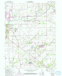
1958 Map of Elizabethtown
USGS Topo · Published 1993About this map
Columbus serves as a primary hub in this portion of Indiana, where the landscape is defined by the convergence of several waterways including Clifty Creek and Otter Creek. The map documents a predominantly agricultural region transitioning toward residential growth, as seen in developments like Jewell Village. Rural community life is anchored by a network of country churches such as Trinity Ch and St Pauls Ch, while the industrial history of the area is hinted at by the remaining Old Railroad Grade cutting through the countryside. Southward, the village of Elizabethtown sits near the junction of Sand Creek and Little Sand Creek, surrounded by several family-named burial grounds like the Donaldson Cem and Springer Cem that provide vital links for local genealogical research.
Find a feature on this map
32 named features on this map. Tap any name to fly to it.
Don’t see what you’re looking for? This feature index may not catch every label — zoom into the map to look around manually.
Map Details
Editions of this 1958 Elizabethtown Map
4 editions found
Other maps of this area

1942 · Columbus
USGS Topo · 1:125,000

1947 · Hope
USGS Topo · 1:24,000

1948 · Edinburg
USGS Topo · 1:24,000

1948 · Hope
USGS Topo · 1:24,000

1950 · Edinburg
USGS Topo · 1:62,500

1953 · Cincinnati
USGS Topo · 1:250,000

1957 · Cincinnati
USGS Topo · 1:250,000

1957 · Jonesville
USGS Topo · 1:24,000

1957 · Azalia
USGS Topo · 1:24,000

1957 · North Vernon
USGS Topo · 1:24,000