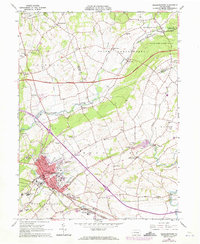
1964 Map of Elizabethtown
USGS Topo · Published 1973About this map
Elizabethtown serves as the focal point of this mid-century survey, showcasing a landscape of education, institutional care, and transit. The campus of Elizabethtown College and the sprawling Masonic Home complex dominate the southern portion of the borough, while the State Hospital sits just to the west. This era finds the region transitioning its rail identity, with the Penn Central line cutting a diagonal path through the township, serving industry hubs like Rheems and Bellaire.
Find a feature on this map
65 named features on this map. Tap any name to fly to it.
Don’t see what you’re looking for? This feature index may not catch every label — zoom into the map to look around manually.
Map Details
Editions of this 1964 Elizabethtown Map
4 editions found
Other maps of this area

1891 · Lebanon
USGS Topo · 1:62,500

1892 · Hummelstown
USGS Topo · 1:62,500

1893 · Lebanon
USGS Topo · 1:62,500

1899 · Lebanon
USGS Topo · 1:62,500

1902 · Lancaster
USGS Topo · 1:62,500

1904 · Lancaster
USGS Topo · 1:62,500

1908 · Middletown
USGS Topo · 1:62,500

1924 · Hummelstown
USGS Topo · 1:62,500

1943 · Lancaster
USGS Topo · 1:62,500

1943 · Lebanon
USGS Topo · 1:62,500
Featured Places
- Elizabethtown, PA
- Mount Joy Township, PA
- Rapho Township, PA
- Bachmanville, Conewago Township
- Conewago Township, PA