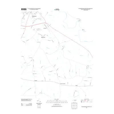
2013 Map of Elizabethtown South
USGS Topo · Published 2013About this map
The Cape Fear River dominates the northeastern landscape of this Bladen County region, where the terrain transitions from the river's winding course to the slightly elevated rises of Big Sugar Loaf and Little Sugar Loaf. South of Elizabethtown, the area is defined by a dense network of blackwater creeks and drainage features such as Hammonds Cr, Pemberton Cr, and the appropriately named Cross Pond. The settlement pattern reflects a rural agricultural and aviation-influenced economy, centered around the Curtis L Brown Jr. Field Airport and the outlying communities of Mount Olive, Lisbon, and Clarks Crossroads. Deep into the southern portion of the sheet, the land becomes increasingly saturated, featuring the broad expanse of Horseshoe Swamp and various branches like Doubles Br and Plum Br that feed into the larger river basin.
Find a feature on this map
93 named features on this map. Tap any name to fly to it.
Don’t see what you’re looking for? This feature index may not catch every label — zoom into the map to look around manually.
Map Details
Editions of this 2013 Elizabethtown South Map
This is the sole edition of this map. No revisions or reprints were ever made.
Other maps of this area

1953 · Florence
USGS Topo · 1:250,000

1954 · Florence
USGS Topo · 1:250,000

1954 · White Lake
USGS Topo · 1:62,500

1954 · Bolton
USGS Topo · 1:62,500

1955 · Whiteville
USGS Topo · 1:62,500

1955 · Elizabethtown
USGS Topo · 1:62,500

1982 · Elizabethtown
USGS Topo · 1:100,000
1986 · Singletary Lake
USGS Topo · 1:24,000
1986 · Council
USGS Topo · 1:24,000

1986 · Whiteville
USGS Topo · 1:100,000