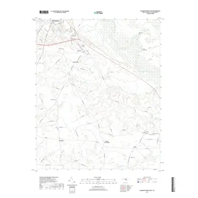
2019 Map of Elizabethtown South
USGS Topo · Published 2019About this map
Elizabethtown and the surrounding Bladen County landscape are defined by the winding course of the Cape Fear River, which carves through a region of complex wetlands and low-lying basins. To the east of the river, distinctive bay features like Cotton Head Bay, Round Pond Bay, and Rice Pond Bay characterize the local geography, alongside elevated landmarks such as Big Sugar Loaf and Little Sugar Loaf. The settlement pattern follows a network of rural roads connecting small communities such as Mount Olive, Bluefield, and Lisbon.
Find a feature on this map
94 named features on this map. Tap any name to fly to it.
Don’t see what you’re looking for? This feature index may not catch every label — zoom into the map to look around manually.
Map Details
Editions of this 2019 Elizabethtown South Map
This is the sole edition of this map. No revisions or reprints were ever made.
Other maps of this area

1953 · Florence
USGS Topo · 1:250,000

1954 · Florence
USGS Topo · 1:250,000

1954 · White Lake
USGS Topo · 1:62,500

1954 · Bolton
USGS Topo · 1:62,500

1955 · Whiteville
USGS Topo · 1:62,500

1955 · Elizabethtown
USGS Topo · 1:62,500

1982 · Elizabethtown
USGS Topo · 1:100,000
1986 · Singletary Lake
USGS Topo · 1:24,000
1986 · Council
USGS Topo · 1:24,000

1986 · Whiteville
USGS Topo · 1:100,000