
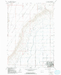
1966 Map of Elk Basin SE
USGS Topo · Published 1969About this map
Powell Flats dominates the landscape of this 1966 survey, revealing the intricate irrigation and road network that defined northern Wyoming agricultural life in the mid-1960s. The town of Powell is situated in the southeastern corner, serving as the hub for a grid of systematically numbered lanes and lateral roads such as Lane Nine and Lateral Ten Road. This layout illustrates the highly organized reclamation and settlement efforts characteristic of the Shoshone Project area. To the west, the topography rises sharply toward the prominent Polecat Bench, a flat-topped landform that contrasts with the fertile valley floor. Water management is central to the area's utility, marked by the Frannie Canal and several pipelines. The map also captures industrial and transport markers of the era, including the Powell Municipal Airport, several Gravel Pits, and a scattering of Drill Holes indicative of regional resource exploration.
Find a feature on this map
26 named features on this map. Tap any name to fly to it.
Don’t see what you’re looking for? This feature index may not catch every label — zoom into the map to look around manually.
Map Details
Editions of this 1966 Elk Basin SE Map
2 editions found
Other maps of this area

1955 · Cody
USGS Topo · 1:250,000

1958 · Cody
USGS Topo · 1:250,000

1962 · Cody
USGS Topo · 1:250,000

1966 · Elk Basin SW
USGS Topo · 1:24,000

1966 · Garland
USGS Topo · 1:24,000

1966 · Elk Basin
USGS Topo · 1:24,000

1966 · Elk Basin NW
USGS Topo · 1:24,000

1966 · Deaver Reservoir
USGS Topo · 1:24,000

1966 · Gilmore Hill NW
USGS Topo · 1:24,000
1966 · Vocation
USGS Topo · 1:24,000