
1956 Map of Elk City
USGS Topo · Published 1963About this map
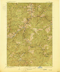
Elk City and the surrounding wilderness of central Idaho are documented here during a period of significant remote industrial activity and forest management. The landscape is dominated by the Salmon River Mountains and Bitterroot Range, where the Salmon River and its numerous forks carve through the terrain. This mid-century survey highlights a regional economy built on isolation and extraction, featuring a dense network of remote outposts like Stibnite and Warren.
Find a feature on this map
180 named features on this map. Tap any name to fly to it.
Don’t see what you’re looking for? This feature index may not catch every label — zoom into the map to look around manually.
Map Details
Editions of this 1956 Elk City Map
3 editions found
Other maps of this area

1901 · Hamilton
USGS Topo · 1:125,000
1909 · Sapphire
USGS Topo · 1:125,000

1911 · Meadows
USGS Topo · 1:125,000

1911 · Lolo
USGS Topo · 1:250,000

1913 · Lolo
USGS Topo · 1:250,000

1924 · Kamiah
USGS Topo · 1:125,000
1924 · Weippe
USGS Topo · 1:125,000
1930 · Casto
USGS Topo · 1:125,000

1931 · Buffalo Hump
USGS Topo · 1:125,000

1934 · Buffalo Hump
USGS Topo · 1:125,000