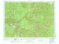
1956 Map of Elk City
USGS Topo · Published 1976About this map
The South Fork Clearwater River and Salmon River carve through a vast high-country landscape that, in the mid-1950s, was characterized by isolated ranching outposts and wilderness mining prospects. This territory is anchored by the Nez Perce Indian Res in the northwest and transitions into the deep backcountry of the Nezperce National Forest and Salmon National Forest. Small settlements like Harpster and Burgdorf serve as primary points of human activity, while numerous family-named landmarks such as Wiley Ranch, Edwards Ranch, and McDowell Ranch indicate the rugged, dispersed nature of habitation during this era.
Find a feature on this map
213 named features on this map. Tap any name to fly to it.
Don’t see what you’re looking for? This feature index may not catch every label — zoom into the map to look around manually.
Map Details
Editions of this 1956 Elk City Map
3 editions found

Other maps of this area

1901 · Hamilton
USGS Topo · 1:125,000

1909 · Sapphire
USGS Topo · 1:125,000

1911 · Meadows
USGS Topo · 1:125,000

1911 · Lolo
USGS Topo · 1:250,000

1913 · Lolo
USGS Topo · 1:250,000

1924 · Kamiah
USGS Topo · 1:125,000

1924 · Weippe
USGS Topo · 1:125,000

1930 · Casto
USGS Topo · 1:125,000

1931 · Buffalo Hump
USGS Topo · 1:125,000

1934 · Buffalo Hump
USGS Topo · 1:125,000