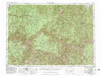
1956 Map of Elk City
USGS Topo · Published 1983About this map
Elk City and the remote mining outposts of the Bitterroot Range anchor this mid-century look at the Central Idaho backcountry. The landscape is defined by massive federal holdings, including the Nezperce National Forest and Payette National Forest, where deep river canyons and mountain ridges dictated the paths of early travel. The Magruder Road and the Lolo Motorway trace high-elevation routes through these protected lands, connecting isolated settlements like Dixie and Warren to the outside world.
Find a feature on this map
182 named features on this map. Tap any name to fly to it.
Don’t see what you’re looking for? This feature index may not catch every label — zoom into the map to look around manually.
Map Details
Editions of this 1956 Elk City Map
3 editions found

Other maps of this area

1901 · Hamilton
USGS Topo · 1:125,000

1909 · Sapphire
USGS Topo · 1:125,000

1911 · Meadows
USGS Topo · 1:125,000

1911 · Lolo
USGS Topo · 1:250,000

1913 · Lolo
USGS Topo · 1:250,000

1924 · Kamiah
USGS Topo · 1:125,000

1924 · Weippe
USGS Topo · 1:125,000

1930 · Casto
USGS Topo · 1:125,000

1931 · Buffalo Hump
USGS Topo · 1:125,000

1934 · Buffalo Hump
USGS Topo · 1:125,000