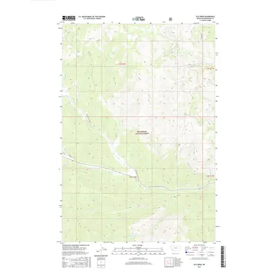
2017 Map of Elk Creek
USGS Topo · Published 2017About this map
Beaverhead National Forest encompasses the entirety of this mountain landscape, which is defined by a complex network of high-country drainages. The Bitterroot-Big Hole Rd provides the primary traverse across the terrain, intersecting with Trail Cr as it follows the natural contours of the land. This 2017 survey illustrates a modern snapshot of federal land management, where primitive roads like Tie Creek Rd and numerous watercourses like Joseph Cr and May Cr dictate the movement of travelers through the wilderness.
Find a feature on this map
25 named features on this map. Tap any name to fly to it.
Don’t see what you’re looking for? This feature index may not catch every label — zoom into the map to look around manually.
Map Details
Editions of this 2017 Elk Creek Map
This is the sole edition of this map. No revisions or reprints were ever made.
Other maps of this area

1955 · Dillon
USGS Topo · 1:250,000

1957 · Dillon
USGS Topo · 1:250,000

1958 · Dillon
USGS Topo · 1:250,000

1962 · Dillon
USGS Topo · 1:250,000

1965 · Dillon
USGS Topo · 1:250,000

1966 · Lost Trail Pass
USGS Topo · 1:24,000

1966 · Big Hole Battlefield
USGS Topo · 1:24,000

1966 · Big Hole Pass
USGS Topo · 1:24,000
1966 · Elk Creek
USGS Topo · 1:24,000
1966 · Isaac Meadows
USGS Topo · 1:24,000