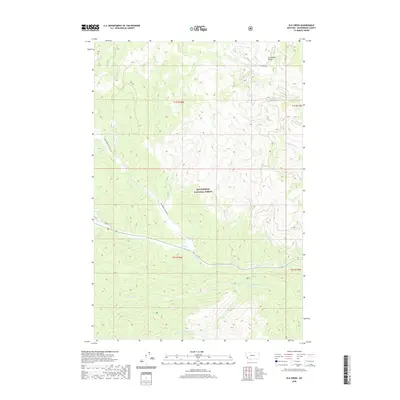
2020 Map of Elk Creek
USGS Topo · Published 2020About this map
Beaverhead National Forest defines the character of this high-altitude landscape in the Anaconda Range, where deep drainages and ridges shape the terrain of Beaverhead County. The map documents a sophisticated network of mountain hydrology, centered on the main stem of Elk Creek and its many tributaries, including Sunshine Creek and Joseph Creek. While largely a wilderness area, human passage is marked by the presence of the Bitterroot-Big Hole Rd and Tie Creek Rd, which provide access through the dense forest and across the divide. A curious point of modern precision is found at the 02S18W23ADDB01 Spring, an identified water source that hints at the detailed hydrological monitoring within the national forest. The layout of section lines and townships, such as t1s r18w, provides a structural grid over the otherwise fluid natural geography of Boulder Creek and May Creek.
Find a feature on this map
26 named features on this map. Tap any name to fly to it.
Don’t see what you’re looking for? This feature index may not catch every label — zoom into the map to look around manually.
Map Details
Editions of this 2020 Elk Creek Map
This is the sole edition of this map. No revisions or reprints were ever made.
Other maps of this area

1955 · Dillon
USGS Topo · 1:250,000

1957 · Dillon
USGS Topo · 1:250,000

1958 · Dillon
USGS Topo · 1:250,000

1962 · Dillon
USGS Topo · 1:250,000

1965 · Dillon
USGS Topo · 1:250,000

1966 · Lost Trail Pass
USGS Topo · 1:24,000

1966 · Big Hole Battlefield
USGS Topo · 1:24,000

1966 · Big Hole Pass
USGS Topo · 1:24,000
1966 · Elk Creek
USGS Topo · 1:24,000
1966 · Isaac Meadows
USGS Topo · 1:24,000