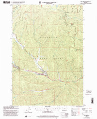
1997 Map of Elk Creek
USGS Topo · Published 2002About this map
Nez Perce (Nee-Me-Poo) National Historic Trail and the Clark and Lewis National Historic Trail both traverse this portion of the Beaverhead National Forest, marking a landscape defined by significant western migratory and Indigenous history. The map detail highlights the intricate drainage systems of the Upper Big Hole Valley area, where Elk Creek and its many tributaries, such as South Fork Elk Creek and Sunshine Creek, carve through the terrain. Evidence of recreational use in the late 20th century is centered around the May Creek Campground, situated near the confluence of Joseph Creek and May Creek. This survey provides a precise look at the forest's topographic character, showing the network of pack trails and primitive routes that follow watercourses like Prairie Creek and Steel Creek as they descend from the high ridges.
Find a feature on this map
19 named features on this map. Tap any name to fly to it.
Don’t see what you’re looking for? This feature index may not catch every label — zoom into the map to look around manually.
Map Details
Editions of this 1997 Elk Creek Map
This is the sole edition of this map. No revisions or reprints were ever made.
Other maps of this area

1955 · Dillon
USGS Topo · 1:250,000

1957 · Dillon
USGS Topo · 1:250,000

1958 · Dillon
USGS Topo · 1:250,000

1962 · Dillon
USGS Topo · 1:250,000

1965 · Dillon
USGS Topo · 1:250,000

1966 · Lost Trail Pass
USGS Topo · 1:24,000

1966 · Big Hole Battlefield
USGS Topo · 1:24,000

1966 · Big Hole Pass
USGS Topo · 1:24,000
1966 · Elk Creek
USGS Topo · 1:24,000
1966 · Isaac Meadows
USGS Topo · 1:24,000