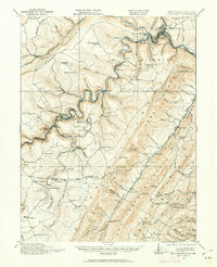
1919 Map of Elk Garden
USGS Topo · Published 1962About this map
Backbone Mountain and the Allegheny Front dominate this region along the West Virginia and Maryland border, where the river-and-rail economy of the early twentieth century is on full display. The Baltimore and Ohio Railroad and the Western Maryland RR follow the winding course of the North Branch of the Potomac, connecting industrial hubs like Westernport and Piedmont. This rugged geography necessitated a dense network of mountain settlements and small schools to support the local workforce.
Find a feature on this map
103 named features on this map. Tap any name to fly to it.
Don’t see what you’re looking for? This feature index may not catch every label — zoom into the map to look around manually.
Map Details
Editions of this 1919 Elk Garden Map
2 editions found

Other maps of this area

1891 · Romney
USGS Topo · 1:125,000

1895 · Piedmont
USGS Topo · 1:125,000

1898 · Frostburg
USGS Topo · 1:62,500

1899 · Grantsville
USGS Topo · 1:62,500

1899 · Oakland
USGS Topo · 1:62,500

1900 · Accident
USGS Topo · 1:62,500

1900 · Oakland
USGS Topo · 1:62,500

1901 · Frostburg
USGS Topo · 1:62,500

1904 · Grantsville
USGS Topo · 1:62,500

1908 · Frostburg
USGS Topo · 1:62,500