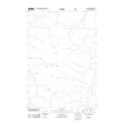
2011 Map of Elk Ridge
USGS Topo · Published 2011About this map
Elk Ridge and Griffin Pass anchor this high-plains landscape in Powder River County, Montana, where a complex network of ephemeral drainages and springs defines the territory. The map reveals an area where water management is critical for ranching, evidenced by the numerous named reservoirs like John Gold Reservoir, Williams Reservoir, and Shell Reservoir. These catchments are linked by a system of creeks, including the winding Little Pumpkin Creek and Cottonwood Creek.
Find a feature on this map
34 named features on this map. Tap any name to fly to it.
Don’t see what you’re looking for? This feature index may not catch every label — zoom into the map to look around manually.
Map Details
Editions of this 2011 Elk Ridge Map
This is the sole edition of this map. No revisions or reprints were ever made.
Other maps of this area

1954 · Ekalaka
USGS Topo · 1:250,000

1956 · Ekalaka
USGS Topo · 1:250,000

1958 · Ekalaka
USGS Topo · 1:250,000

1965 · Ekalaka
USGS Topo · 1:250,000

1966 · Stacey
USGS Topo · 1:24,000

1966 · Home Creek Butte
USGS Topo · 1:24,000

1966 · Elk Ridge
USGS Topo · 1:24,000

1966 · Samuelson Ranch
USGS Topo · 1:24,000
1973 · North Stacey School
USGS Topo · 1:24,000

1973 · Box Elder Creek
USGS Topo · 1:24,000