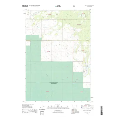
2020 Map of Elk Springs
USGS Topo · Published 2020About this map
The Red Rock Lakes National Wildlife Refuge and Beaverhead National Forest dominate this high-altitude landscape along the Madison Co Beaverhead Co line. The map captures a critical transition in the Centennial Valley, where the extensive wetlands of Upper Red Rock Lake and Swan Lake give way to the rising slopes of the Centennial Mountains. This hydrologically significant area is marked by numerous water sources, including the namesake Elk Springs, Culver Springs, and Two Drink Springs, which feed a complex network of creeks like Brimstone Cr and Horse Cr. Mountain passes such as Snowshoe Pass and Hoodoo Pass provide historical transit points through the high country, while Elk Lake Rd and N Valley Rd trace the lower elevations near Elk Lake and its distinctive narrow waterway known as The Narrows.
Find a feature on this map
37 named features on this map. Tap any name to fly to it.
Don’t see what you’re looking for? This feature index may not catch every label — zoom into the map to look around manually.
Map Details
Editions of this 2020 Elk Springs Map
This is the sole edition of this map. No revisions or reprints were ever made.
Other maps of this area

1950 · Cliff Lake
USGS Topo · 1:62,500

1950 · Lower Red Rock Lake
USGS Topo · 1:62,500

1950 · Monument Ridge
USGS Topo · 1:62,500

1950 · Upper Red Rock Lake
USGS Topo · 1:62,500

1955 · Ashton
USGS Topo · 1:250,000

1958 · Ashton
USGS Topo · 1:250,000

1960 · Ashton
USGS Topo · 1:250,000
1988 · Hidden Lake Bench
USGS Topo · 1:24,000
1988 · Freezeout Mountain
USGS Topo · 1:24,000
1988 · Lower Red Rock Lake
USGS Topo · 1:24,000