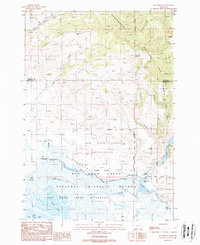
1988 Map of Elk Springs
USGS Topo · Published 1988About this map
The Centennial Valley anchors this high-elevation landscape where the Beaverhead Mountains meet the waters of the Red Rock Lakes National Wildlife Refuge. The map traces a complex network of high-country drainage, from the West Fork Madison River in the north to Raynolds Creek and the marshy expanses of Swan Lake in the south. This area serves as a critical hydrological and wildlife corridor, marked by specialized features like the Lookout Tower and various isolated watering points such as Two Drink Springs and Antelope Pond.
Find a feature on this map
36 named features on this map. Tap any name to fly to it.
Don’t see what you’re looking for? This feature index may not catch every label — zoom into the map to look around manually.
Map Details
Editions of this 1988 Elk Springs Map
This is the sole edition of this map. No revisions or reprints were ever made.
Other maps of this area

1950 · Cliff Lake
USGS Topo · 1:62,500

1950 · Lower Red Rock Lake
USGS Topo · 1:62,500

1950 · Monument Ridge
USGS Topo · 1:62,500

1950 · Upper Red Rock Lake
USGS Topo · 1:62,500

1955 · Ashton
USGS Topo · 1:250,000

1958 · Ashton
USGS Topo · 1:250,000

1960 · Ashton
USGS Topo · 1:250,000
1988 · Hidden Lake Bench
USGS Topo · 1:24,000
1988 · Freezeout Mountain
USGS Topo · 1:24,000
1988 · Lower Red Rock Lake
USGS Topo · 1:24,000