
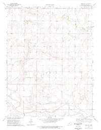
1972 Map of Elkader NE
USGS Topo · Published 1974About this map
Hackberry Creek and its various tributaries define the drainage patterns of this High Plains landscape along the boundary of Logan and Gove Counties. The terrain is marked by the distinct upland areas of Oakley, Gaeland O, and Elkader, where the prairie surface breaks into a series of draws and ridges shaped by the Middle Branch and South Branch of Hackberry Creek. This 1972 field-checked survey provides a look at the rural character of the region before modern agricultural shifts, documenting a network of section-line roads and scattered wells that supported the local ranching and farming economy. Water remains the primary geographical driver, with Plum Creek carving through the southern portion of the quadrangle, illustrating the importance of these seasonal waterways in an otherwise arid Kansas environment.
Find a feature on this map
8 named features on this map. Tap any name to fly to it.
Don’t see what you’re looking for? This feature index may not catch every label — zoom into the map to look around manually.
Map Details
Editions of this 1972 Elkader NE Map
This is the sole edition of this map. No revisions or reprints were ever made.
Other maps of this area

1954 · Goodland
USGS Topo · 1:250,000

1955 · Scott City
USGS Topo · 1:250,000

1956 · Goodland
USGS Topo · 1:250,000

1957 · Goodland
USGS Topo · 1:250,000

1958 · Scott City
USGS Topo · 1:250,000

1972 · Elkader NW
USGS Topo · 1:24,000

1972 · Orion
USGS Topo · 1:24,000

1974 · Elkader SW
USGS Topo · 1:24,000

1974 · Elkader
USGS Topo · 1:24,000
1974 · Orion SW
USGS Topo · 1:24,000