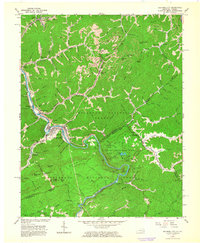
1963 Map of Elkhorn City
USGS Topo · Published 1964About this map
Russell Fork carves a deep, winding path through the borderlands of Kentucky and Virginia, serving as the central artery for Elkhorn City. This 1963 survey illustrates a landscape shaped by coal extraction and heavy rail transport, with numerous Strip Mines dotting the ridges and the Chesapeake and Ohio and Clinchfield railroads following the river's tight bends. The industrial character of the region, evidenced by the Mikegrady Substation and various gas wells, is contrasted by the preservation of the Breaks Interstate Park and Jefferson National Forest. Notable for genealogists are the family-named cemeteries and rural institutions such as Mullins Cemetery, Willis Cemetery, and Honey Fork Church. The intricate topography includes landmark formations like The Chimney and The Towers, along with several railroad tunnels such as the Pool Point Tunnel and State Line Tunnel that pierce the steep terrain.
Find a feature on this map
112 named features on this map. Tap any name to fly to it.
Don’t see what you’re looking for? This feature index may not catch every label — zoom into the map to look around manually.
Map Details
Editions of this 1963 Elkhorn City Map
3 editions found
Other maps of this area

1886 · Grundy
USGS Topo · 1:125,000

1890 · Grundy
USGS Topo · 1:125,000

1892 · Grundy
USGS Topo · 1:125,000

1913 · Clintwood
USGS Topo · 1:62,500

1914 · Bucu
USGS Topo · 1:48,000

1914 · Hurley
USGS Topo · 1:48,000

1915 · Clintwood
USGS Topo · 1:62,500

1915 · Regina
USGS Topo · 1:48,000

1915 · Hurley
USGS Topo · 1:48,000

1916 · Bucu
USGS Topo · 1:62,500