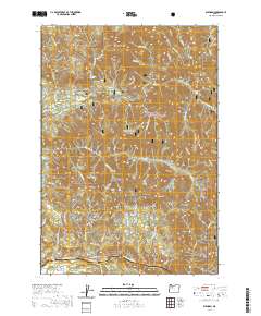
2020 Map of Elkhorn
USGS Topo · Published 2020About this map
The Little North Santiam River and its numerous tributaries, including Henline Cr and Cedar Cr, define this landscape within the Willamette National Forest. This 2020 survey documents the rugged canyon country of Marion and Linn counties, where high points like Mt Horeb and Henline Mtn rise above narrow valleys. The settlement of Elkhorn and the community of Niagara sit along the river corridors, connected by forest roads such as Niagara Heights Rd and Mount Horeb Rd SE. Significant water features like Henline Falls and Salmon Falls indicate the steep drops common in the western Cascades. Farther south, the North Santiam River flows past the Gates Brg E, while protected areas like the Elkhorn Creek Wild and Scenic River preserve the natural character of the drainage between Buck Mtn and Elkhorn Ridge.
Find a feature on this map
69 named features on this map. Tap any name to fly to it.
Don’t see what you’re looking for? This feature index may not catch every label — zoom into the map to look around manually.
Map Details
Editions of this 2020 Elkhorn Map
This is the sole edition of this map. No revisions or reprints were ever made.
Other maps of this area

1929 · Mill City
USGS Topo · 1:125,000

1953 · Salem
USGS Topo · 1:250,000

1954 · Salem
USGS Topo · 1:250,000

1955 · Mill City
USGS Topo · 1:62,500

1956 · Quartzville
USGS Topo · 1:62,500

1956 · Battle Ax
USGS Topo · 1:62,500

1956 · Detroit
USGS Topo · 1:62,500

1960 · Salem
USGS Topo · 1:250,000

1962 · Salem
USGS Topo · 1:250,000

1963 · Salem
USGS Topo · 1:250,000