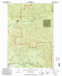
1994 Map of Elkhorn
USGS Topo · Published 1998About this map
The Little North Santiam River carves through the heavily forested canyons of Marion County, anchoring a landscape defined by timber and early recreation. Small settlements such as Elkhorn and Niagara sit along the riverbanks, with the latter marked by the Niagara Dam and Niagara Park (County). The complex topography includes high points like Mount Horeb and Henline Mountain, providing a backdrop for numerous tributaries such as Sardine Creek and Cedar Creek. To the east, the Big Cliff Res marks the controlled flow of the river system, while locations like Little Sweden hint at local history and earlier settlement patterns. The map details a network of 4WD roads and trails traversing the Willamette National Forest and Santiam State Forest, highlighting areas like the Bull of the Woods Wilderness and Salmon Falls Park (County).
Find a feature on this map
53 named features on this map. Tap any name to fly to it.
Don’t see what you’re looking for? This feature index may not catch every label — zoom into the map to look around manually.
Map Details
Editions of this 1994 Elkhorn Map
This is the sole edition of this map. No revisions or reprints were ever made.
Other maps of this area

1929 · Mill City
USGS Topo · 1:125,000

1953 · Salem
USGS Topo · 1:250,000

1954 · Salem
USGS Topo · 1:250,000

1955 · Mill City
USGS Topo · 1:62,500

1956 · Quartzville
USGS Topo · 1:62,500

1956 · Battle Ax
USGS Topo · 1:62,500

1956 · Detroit
USGS Topo · 1:62,500

1960 · Salem
USGS Topo · 1:250,000

1962 · Salem
USGS Topo · 1:250,000

1963 · Salem
USGS Topo · 1:250,000