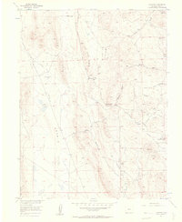
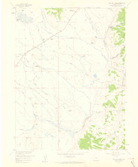
1956 Map of Elkhorn
USGS Topo · Published 1957About this map
Elkhorn Ranch and the nearby Elkhorn Community House serve as the primary human touchpoints in this 1950s survey of high-elevation Colorado territory. The landscape is defined by the massive The Basin to the west, separated from the deeply etched ravines of Elkhorn Gulch and Sevenmile Gulch by the prominent Mexican Ridge. This era represents a period when water management was paramount for ranching and settlement, evidenced by the named water sources like Garcia Spring, Association Spring, and Lone Tree Springs. Local infrastructure of the day is traced through the winding Ruby Road and the Aqueduct crossing the northern terrain. The presence of Playa Lakes suggests a seasonal hydrological cycle typical of the region, while landmarks like Logan Hill provided essential orientation for those navigating the gulches and ridges of Park County.
Find a feature on this map
23 named features on this map. Tap any name to fly to it.
Don’t see what you’re looking for? This feature index may not catch every label — zoom into the map to look around manually.
Map Details
Editions of this 1956 Elkhorn Map
5 editions found
Other maps of this area

1937 · Como
USGS Topo · 1:62,500

1953 · Denver
USGS Topo · 1:250,000

1956 · Eagle Rock
USGS Topo · 1:24,000

1956 · Elkhorn
USGS Topo · 1:24,000

1956 · Sulphur Mountain
USGS Topo · 1:24,000

1956 · Garo
USGS Topo · 1:24,000

1956 · Fairplay East
USGS Topo · 1:24,000

1956 · Hartsel
USGS Topo · 1:24,000

1957 · Denver
USGS Topo · 1:250,000
1957 · Milligan Lakes
USGS Topo · 1:24,000