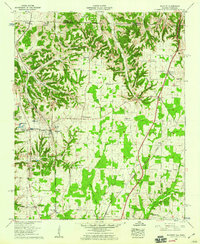
1958 Map of Elkmont
USGS Topo · Published 1959About this map
The Louisville And Nashville railroad carves a central path through this late 1950s landscape, connecting the town of Elkmont with smaller rural hubs like Pettusville and Veto. This area on the Tennessee-Alabama border is characterized by a dense network of family-named cemeteries and community landmarks, such as the Harlow Cem and Payne Cem in the north and the Reunion Ch to the south. Local industry and agriculture are evidenced by the Holland Gin and Woodin Mill, while education and social life centered on locations like Scott Sch and Thach Sch. Terrain features such as McCathey Hollow and Redus Hollow define the drainage patterns feeding into Muddy Creek and Sulphur Creek, illustrating the traditional upland settlement patterns before modern development altered the rural character of Limestone County.
Find a feature on this map
50 named features on this map. Tap any name to fly to it.
Don’t see what you’re looking for? This feature index may not catch every label — zoom into the map to look around manually.
Map Details
Editions of this 1958 Elkmont Map
2 editions found
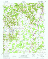
Other maps of this area

1888 · Huntsville
USGS Topo · 1:125,000

1892 · Huntsville
USGS Topo · 1:125,000

1935 · Athens
USGS Topo · 1:24,000

1936 · Capshaw
USGS Topo · 1:24,000

1936 · Aspen Hill
USGS Topo · 1:24,000

1936 · Elkmont
USGS Topo · 1:24,000

1936 · Ripley
USGS Topo · 1:24,000

1936 · Ardmore
USGS Topo · 1:24,000

1936 · Elkton
USGS Topo · 1:24,000

1936 · Dellrose
USGS Topo · 1:24,000