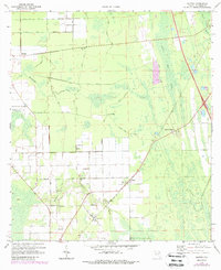
1970 Map of Elkton
USGS Topo · Published 1988About this map
Elkton and the surrounding agricultural lands of St. Johns County are documented in this 1970 survey, reflecting the area's transition into the late 20th century. The settlement pattern is defined by rural crossroads and family-named landmarks, such as Molasses Junction and Vermont Heights. Significant community centers including St Ambrose Ch and Zion Hill Ch are captured alongside the Fairgrounds, indicating the local social and economic hubs of the period.
Find a feature on this map
33 named features on this map. Tap any name to fly to it.
Don’t see what you’re looking for? This feature index may not catch every label — zoom into the map to look around manually.
Map Details
Editions of this 1970 Elkton Map
3 editions found
Other maps of this area

1912 · Palatka
USGS Topo · 1:48,000

1915 · Palatka
USGS Topo · 1:62,500

1937 · Bakersville
USGS Topo · 1:24,000

1937 · Elkton
USGS Topo · 1:24,000

1937 · Crescent Beach
USGS Topo · 1:24,000

1937 · Dinner Island
USGS Topo · 1:48,000

1937 · St. Augustine
USGS Topo · 1:24,000

1943 · St. Augustine
USGS Topo · 1:62,500

1943 · Dinner Island
USGS Topo · 1:62,500

1944 · Dinner Island
USGS Topo · 1:62,500