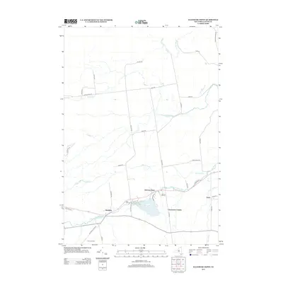
2013 Map of Ellenburg Depot
USGS Topo · Published 2013About this map
Ellenburg Depot and the surrounding Clinton County countryside appear here as a landscape defined by its waterways and rural roads. The northern reach of the township is drained by the English River and Allen Brook, while the southern corridor follows the path of the N Br Great Chazy River. This area reflects a long-standing agricultural and residential pattern, with distinct local landmarks such as Silver Lane Dairy and historically significant sites like Saint Edmunds Cem and Sheldon Hill Cem. The map documents a network of named thoroughfares, including Clinton Mills RD and Lake Roxanne RD, which connect small settlements like Forest and Dannemora Crossing to the primary hub at Ellenburg.
Find a feature on this map
40 named features on this map. Tap any name to fly to it.
Don’t see what you’re looking for? This feature index may not catch every label — zoom into the map to look around manually.
Map Details
Editions of this 2013 Ellenburg Depot Map
This is the sole edition of this map. No revisions or reprints were ever made.
Other maps of this area

1895 · Mooers
USGS Topo · 1:62,500

1899 · Mooers
USGS Topo · 1:62,500

1915 · Churubusco
USGS Topo · 1:62,500

1942 · Mooers
USGS Topo · 1:62,500

1943 · Churubusco
USGS Topo · 1:62,500

1943 · Mooers
USGS Topo · 1:62,500

1950 · Lake Champlain
USGS Topo · 1:250,000
1956 · Mooers
USGS Topo · 1:62,500

1958 · Lake Champlain
USGS Topo · 1:250,000

1962 · Lake Champlain
USGS Topo · 1:250,000