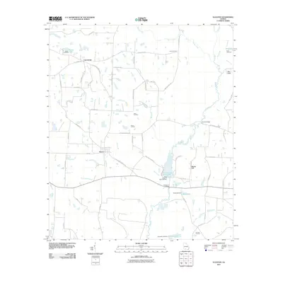
2011 Map of Ellenton
USGS Topo · Published 2011About this map
Ellenton and Cool Springs anchor this south Georgia landscape, where the Little River and its many tributaries, such as Warrior Creek and Bull Creek, dictate the geography. The map reveals a high density of family-named roads and landmarks, highlighting the area's ancestral ties through sites like Vickers Cemetery, Baker Cemetery, and Folsom Cemetery. The southern portion of the quadrangle is dominated by the waters of Reed Bingham Park Lake, formed by the Reed Bingham Park Lake Dam. This 2011 survey captures the transition of the rural economy, where traditional creek-side crossings like Flat Ford and Whitehurst Bridge coexist with modern developments. The presence of several managed water bodies, including Pervis Lake, Grist Lake, and Saunders Lake, suggests a landscape heavily modified for recreation and agricultural water management, while Burney Hill provides a rare point of elevation in the otherwise low-lying drainage basins of Buck Creek and Mill Creek.
Find a feature on this map
72 named features on this map. Tap any name to fly to it.
Don’t see what you’re looking for? This feature index may not catch every label — zoom into the map to look around manually.
Map Details
Editions of this 2011 Ellenton Map
This is the sole edition of this map. No revisions or reprints were ever made.
Other maps of this area

1953 · Waycross
USGS Topo · 1:250,000

1958 · Waycross
USGS Topo · 1:250,000

1973 · Norman Park
USGS Topo · 1:24,000

1973 · Adel
USGS Topo · 1:24,000

1973 · Cecil
USGS Topo · 1:24,000

1973 · Lenox
USGS Topo · 1:24,000

1973 · Omega
USGS Topo · 1:24,000

1974 · Berlin East
USGS Topo · 1:24,000

1974 · Pineboro
USGS Topo · 1:24,000
1974 · Ellenton
USGS Topo · 1:24,000