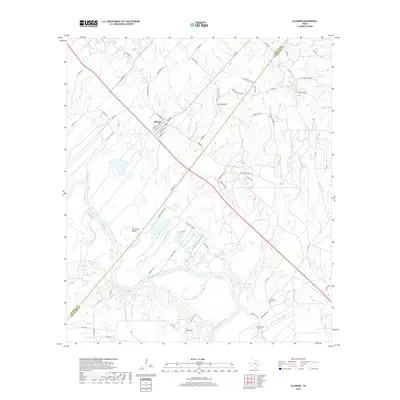
2019 Map of Ellinger
USGS Topo · Published 2019About this map
Ellinger serves as the central hub of this survey, located where FM 955 meets a network of local streets such as Grover ST and Forstrand ST. The landscape is defined by the winding course of the Colorado River, which carves a sharp path through the southern half of the quadrangle. This riverine geography includes the prominent Horseshoe Bend, a significant hydrologic feature that has shaped local land use and transportation routes like Burnham Ferry Rd. In the east, the terrain rises toward Rocky Hill and Live Oak Hill, punctuating the relatively level agricultural and ranching lands that dominate the region.
Find a feature on this map
70 named features on this map. Tap any name to fly to it.
Don’t see what you’re looking for? This feature index may not catch every label — zoom into the map to look around manually.
Map Details
Editions of this 2019 Ellinger Map
This is the sole edition of this map. No revisions or reprints were ever made.
Other maps of this area
1919 · Fayettsville
USGS Topo · 1:62,500
1919 · Schulenburg
USGS Topo · 1:62,500

1953 · Seguin
USGS Topo · 1:250,000
1956 · Glidden
USGS Topo · 1:62,500
1956 · La Grange
USGS Topo · 1:62,500
1957 · Ellinger
USGS Topo · 1:24,000
1957 · La Grange East
USGS Topo · 1:24,000
1957 · Columbus
USGS Topo · 1:24,000
1957 · Borden
USGS Topo · 1:24,000
1957 · Ammannsville
USGS Topo · 1:24,000