
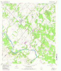
1957 Map of Ellinger
USGS Topo · Published 1958About this map
The settlement of Ellinger serves as a central landmark in this late-1950s survey of the Texas coastal plain near the Colorado River. The landscape is defined by the winding river and its significant geographic features like Horseshoe Bend, surrounded by a dense network of tributaries including Pettys Creek and Crier Creek. Evidence of earlier transport infrastructure is visible in the Old Railroad Grade cutting across the northwestern quadrant, while local industry is represented by a Strip Mine and Gravel Pit. For those researching family history in Fayette and Colorado Counties, the map identifies several local landmarks and burial sites, such as the Rocky Hill Sch, Brushy Sch, and rural cemeteries including Shaws Bend Cem, Adkins Cem, and Boettcher Cem.
Find a feature on this map
28 named features on this map. Tap any name to fly to it.
Don’t see what you’re looking for? This feature index may not catch every label — zoom into the map to look around manually.
Map Details
Editions of this 1957 Ellinger Map
2 editions found
Other maps of this area

1919 · Fayettsville
USGS Topo · 1:62,500

1919 · Schulenburg
USGS Topo · 1:62,500

1953 · Seguin
USGS Topo · 1:250,000

1956 · Glidden
USGS Topo · 1:62,500

1956 · La Grange
USGS Topo · 1:62,500

1957 · La Grange East
USGS Topo · 1:24,000

1957 · Columbus
USGS Topo · 1:24,000

1957 · Borden
USGS Topo · 1:24,000

1957 · Ammannsville
USGS Topo · 1:24,000

1958 · Seguin
USGS Topo · 1:250,000