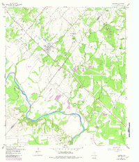
1957 Map of Ellinger
USGS Topo · Published 1982About this map
Ellinger serves as the focal point of this mid-century survey, situated at the intersection of local commerce and transportation. The landscape is defined by the winding course of the Colorado River, which forms the prominent Horseshoe Bend as it flows toward the county line. Evidence of former infrastructure is visible in the Old Railroad Grade cutting across the northern terrain, indicating the shift in transport patterns that shaped these communities.
Find a feature on this map
29 named features on this map. Tap any name to fly to it.
Don’t see what you’re looking for? This feature index may not catch every label — zoom into the map to look around manually.
Map Details
Editions of this 1957 Ellinger Map
2 editions found
Other maps of this area

1919 · Fayettsville
USGS Topo · 1:62,500

1919 · Schulenburg
USGS Topo · 1:62,500

1953 · Seguin
USGS Topo · 1:250,000

1956 · Glidden
USGS Topo · 1:62,500

1956 · La Grange
USGS Topo · 1:62,500

1957 · Ellinger
USGS Topo · 1:24,000

1957 · La Grange East
USGS Topo · 1:24,000

1957 · Columbus
USGS Topo · 1:24,000

1957 · Borden
USGS Topo · 1:24,000

1957 · Ammannsville
USGS Topo · 1:24,000