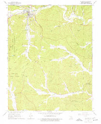
1968 Map of Ellington
USGS Topo · Published 1977About this map
Ellington serves as the primary hub in this late 1960s Ozark landscape, where the town's grid meets the curving waters of Logan Creek. The map reveals a deeply dissected terrain characterized by numerous family-named valleys such as Dickson Valley and Darr Valley. Evidence of earlier industrial transport is visible in the Old Railroad Grade winding through the western hills, while the Deer Run Lookout Tower stands as a sentinel over the surrounding Deer Run State Forest. For local historians and genealogists, the sheet is exceptionally well-marked with burial grounds, including the Ellington Memorial Cem, Chitwood Cem, and Dickson Cem. The settlement pattern follows the hollows and creek beds, with Bethlehem Ch and the small community of Ruble anchoring the southern reaches near Webb Creek.
Find a feature on this map
46 named features on this map. Tap any name to fly to it.
Don’t see what you’re looking for? This feature index may not catch every label — zoom into the map to look around manually.
Map Details
Editions of this 1968 Ellington Map
3 editions found
Other maps of this area

1928 · Cardareva
USGS Topo · 1:62,500

1943 · Ellington
USGS Topo · 1:62,500

1943 · Lesterville
USGS Topo · 1:62,500

1944 · Corridon
USGS Topo · 1:62,500

1945 · Ellington
USGS Topo · 1:62,500

1946 · Lesterville
USGS Topo · 1:62,500

1947 · Corridon
USGS Topo · 1:62,500

1949 · Rolla
USGS Topo · 1:250,000

1949 · Cardareva
USGS Topo · 1:62,500

1953 · Rolla
USGS Topo · 1:250,000