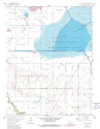
1956 Map of Ellinwood NW
USGS Topo · Published 1980About this map
Cheyenne Bottoms State Waterfowl Refuge dominates this Central Kansas landscape, revealing the complex water management systems of the mid-20th century. Based on 1950s surveys with revisions from the late 1970s, the map illustrates the massive scale of the Cheyenne Bottoms basin and the engineering required to maintain its ecosystem, including the Inlet Canal, Outlet Canal, and various Floodgates. To the south and west, the terrain shifts into the agricultural reaches of Great Bend and South Homestead, where natural drainage is provided by Blood Creek and Walnut Creek. The map is particularly notable for its documentation of energy extraction, with numerous Oil Wells scattered across the township lines of Lakin. This intersection of heavy industry and environmental conservation defines the era's approach to the Barton County landscape.
Find a feature on this map
16 named features on this map. Tap any name to fly to it.
Don’t see what you’re looking for? This feature index may not catch every label — zoom into the map to look around manually.
Map Details
Editions of this 1956 Ellinwood NW Map
2 editions found
Other maps of this area

1891 · Great Bend
USGS Topo · 1:125,000

1893 · Great Bend
USGS Topo · 1:125,000

1896 · Russell
USGS Topo · 1:125,000

1955 · Great Bend
USGS Topo · 1:250,000

1956 · Ellinwood NE
USGS Topo · 1:24,000

1956 · Ellinwood NW
USGS Topo · 1:24,000

1957 · Great Bend
USGS Topo · 1:250,000

1957 · Ellinwood SW
USGS Topo · 1:24,000

1957 · Ellinwood
USGS Topo · 1:24,000

1958 · Great Bend
USGS Topo · 1:250,000