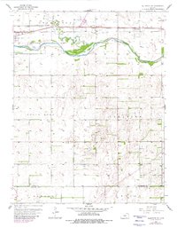
1957 Map of Ellinwood SW
USGS Topo · Published 1980About this map
Fort Zarah Park marks a significant historical waypoint just east of Great Bend, situated near the confluence of Walnut Creek and the Arkansas River. This late-1950s landscape, later updated in the 1970s, illustrates the heavy industrial footprint of central Kansas through the pervasive Oil Field infrastructure scattered across the Comanche and South Bend townships. The transportation corridor is dominated by the Atchison Topeka and Santa Fe railroad, which runs parallel to the river and connects the larger hub of Great Bend to the smaller siding at Dartmouth. South of the river, the terrain shifts into more irregular contours and sand hills, contrasting with the leveled, levee-protected agricultural and industrial lands to the north. These details, including a prominent Radio Tower and the Sewage Disposal plant, reflect the mid-century municipal growth of the region.
Find a feature on this map
19 named features on this map. Tap any name to fly to it.
Don’t see what you’re looking for? This feature index may not catch every label — zoom into the map to look around manually.
Map Details
Editions of this 1957 Ellinwood SW Map
2 editions found
Other maps of this area

1891 · Great Bend
USGS Topo · 1:125,000

1893 · Great Bend
USGS Topo · 1:125,000

1955 · Great Bend
USGS Topo · 1:250,000

1956 · Ellinwood NE
USGS Topo · 1:24,000

1956 · Ellinwood NW
USGS Topo · 1:24,000

1957 · Great Bend
USGS Topo · 1:250,000

1957 · Ellinwood SW
USGS Topo · 1:24,000

1957 · Ellinwood
USGS Topo · 1:24,000

1958 · Great Bend
USGS Topo · 1:250,000

1958 · Great Bend
USGS Topo · 1:24,000