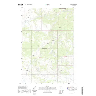
2020 Map of Ellis Canyon
USGS Topo · Published 2020About this map
The Helena National Forest dominates this Meagher County landscape, where the Smith River cuts through the northeast corner. This section of the Big Belt Mountains is defined by sharp topographic reliefs and a network of drainages including Ellis Canyon and its eastern and western forks. The area exhibits a classic mountain-ranching geography, evidenced by features such as Haystack Bar and Dry Range, along with critical water sources like Haystack Spring and Weaning Corral Spring. Human activity is sparse, marked primarily by the winding route of Lingshire Rd and Co RD 360, which follow natural contours to provide access to the high country. In the southern portion of the quadrangle, Dry Beaver Cr and the Ashford Tank reflect the seasonal nature of water management in this high-elevation environment, while Buffalo Canyon and Den Gulch carve into the heavily forested slopes.
Find a feature on this map
26 named features on this map. Tap any name to fly to it.
Don’t see what you’re looking for? This feature index may not catch every label — zoom into the map to look around manually.
Map Details
Editions of this 2020 Ellis Canyon Map
This is the sole edition of this map. No revisions or reprints were ever made.
Other maps of this area
1886 · Fort Logan
USGS Topo · 1:250,000
1948 · White Sulphur Springs
USGS Topo · 1:250,000
1958 · White Sulphur Springs
USGS Topo · 1:250,000
1961 · White Sulphur Springs
USGS Topo · 1:250,000
1965 · White Sulphur Springs
USGS Topo · 1:250,000
1966 · Lingshire
USGS Topo · 1:24,000
1966 · Whites City
USGS Topo · 1:24,000
1966 · Watson
USGS Topo · 1:24,000
1966 · Lingshire NE
USGS Topo · 1:24,000
1966 · Ellis Canyon
USGS Topo · 1:24,000