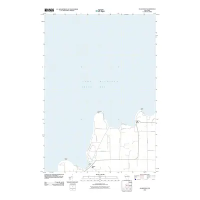
2010 Map of Ellison Bay
USGS Topo · Published 2010About this map
Lake Michigan and Green Bay meet at the northern tip of the Door Peninsula, where the landscape is defined by the high limestone escarpments of Deathdoor Bluff and Table Bluff. This 2010 survey of the Ellison Bay area captures the coastal character of Door County, showing the cluster of maritime activity at Gills Rock and the vacation cottages at Cedar Grove Resort. The network of local roads, such as Wisconsin Bay Rd and Door Bluff Park Rd, traces the shoreline and interior woods, illustrating the modern balance between residential life and the preserved natural bluffs. The naming of the bluffs themselves provides a clear indicator of the navigational hazards and dramatic topography that have long influenced the region's development and its local identity as a crossroads of the Great Lakes.
Find a feature on this map
23 named features on this map. Tap any name to fly to it.
Don’t see what you’re looking for? This feature index may not catch every label — zoom into the map to look around manually.
Map Details
Editions of this 2010 Ellison Bay Map
This is the sole edition of this map. No revisions or reprints were ever made.
Other maps of this area

1954 · Escanaba
USGS Topo · 1:250,000

1957 · Escanaba
USGS Topo · 1:250,000

1958 · Escanaba
USGS Topo · 1:250,000

1960 · Washington Island
USGS Topo · 1:62,500

1960 · Sister Bay
USGS Topo · 1:62,500

1960 · Ellison Bay
USGS Topo · 1:62,500

1981 · Marinette
USGS Topo · 1:100,000

1982 · Washington Island NW
USGS Topo · 1:24,000
1982 · Ellison Bay
USGS Topo · 1:24,000
1982 · Washington Island SW
USGS Topo · 1:24,000