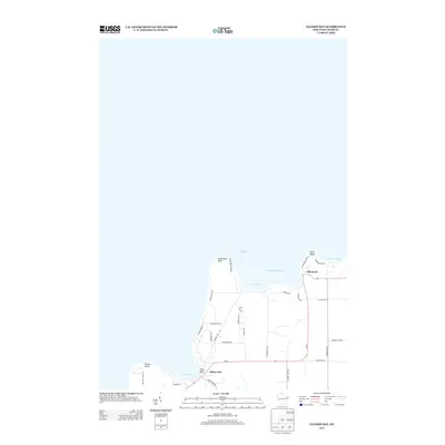
2013 Map of Ellison Bay
USGS Topo · Published 2013About this map
Deathdoor Bluff and Table Bluff anchor the northern reaches of the Door Peninsula, overlooking the waters of Lake Michigan. This 2013 survey of the northern tip shows a coastline defined by deep inlets such as Hedgehog Harbor and Garret Bay. The settlement patterns follow the shoreline, with Gills Rock situated at the northern terminus and the community of Ellison Bay tucked into the southwest corner. Inland, the map reveals a grid of rural lanes like Mink River Rd and Blackberry Rd that service the orchards and wooded tracts typical of this maritime region. The placement of the Cedar Grove Resort and numerous residential lanes such as Cottage Rd and Isle View Rd illustrates the long-standing recreational and seasonal character of the Door County shoreline as it appeared in the early 21st century.
Find a feature on this map
35 named features on this map. Tap any name to fly to it.
Don’t see what you’re looking for? This feature index may not catch every label — zoom into the map to look around manually.
Map Details
Editions of this 2013 Ellison Bay Map
This is the sole edition of this map. No revisions or reprints were ever made.
Other maps of this area

1954 · Escanaba
USGS Topo · 1:250,000

1957 · Escanaba
USGS Topo · 1:250,000

1958 · Escanaba
USGS Topo · 1:250,000

1960 · Washington Island
USGS Topo · 1:62,500

1960 · Sister Bay
USGS Topo · 1:62,500

1960 · Ellison Bay
USGS Topo · 1:62,500

1981 · Marinette
USGS Topo · 1:100,000

1982 · Washington Island NW
USGS Topo · 1:24,000
1982 · Ellison Bay
USGS Topo · 1:24,000
1982 · Washington Island SW
USGS Topo · 1:24,000