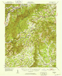
1950 Map of Elliston
USGS Topo · Published 1952About this map
Bent Mountain and the high ridges of the Blue Ridge define this landscape, where the headwaters of the South Fork Roanoke River and the Little River carve through the borderlands of Montgomery, Roanoke, Floyd, and Franklin counties. In the early 1950s, the region maintained a rural character shaped by significant elevation changes, with the Appalachian Trail winding across the southern slopes near Check High Sch. The Norfolk and Western railway and the Virginian line follow the valley floor through Elliston and Shawsville, supporting small communities like Lafayette and Riverside. This survey captures the transition from valley floor settlements to upland plateaus, where isolated churches like Kittingers Chapel and Mt Olivet Ch served dispersed mountain residents. Cultural landmarks such as the YMCA Camp and Camp Kiwanianna highlight the area's mid-century role as a recreational retreat, while several scenic overlooks along the southern heights provide views across the Blackwater River drainage.
Find a feature on this map
84 named features on this map. Tap any name to fly to it.
Don’t see what you’re looking for? This feature index may not catch every label — zoom into the map to look around manually.
Map Details
Editions of this 1950 Elliston Map
4 editions found

Other maps of this area

1890 · Roanoke
USGS Topo · 1:125,000

1890 · Christiansburg
USGS Topo · 1:125,000

1891 · Roanoke
USGS Topo · 1:125,000

1923 · Waiteville
USGS Topo · 1:62,500

1925 · Rocky Mount
USGS Topo · 1:48,000

1927 · Rocky Mount
USGS Topo · 1:62,500

1929 · Roanoke
USGS Topo · 1:48,000

1929 · Salem
USGS Topo · 1:48,000

1931 · Waiteville
USGS Topo · 1:48,000

1932 · Salem
USGS Topo · 1:62,500