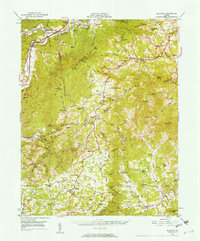
1950 Map of Elliston
USGS Topo · Published 1957About this map
The Lee Highway and parallel rail lines of the Virginian RR and Norfolk and Western RR dictate the settlement pattern along the Roanoke River valley in this 1950s study. Small communities like Lafayette and Shawsville sit at the base of Poor Mountain, while the winding Blue Ridge Parkway traces the higher elevations to the south. The map documents a rural landscape transitioning toward mid-century infrastructure, evidenced by several scattered radio towers such as the Radio Mast (WSLS) and the Radio Tower (WDBJ).
Find a feature on this map
108 named features on this map. Tap any name to fly to it.
Don’t see what you’re looking for? This feature index may not catch every label — zoom into the map to look around manually.
Map Details
Editions of this 1950 Elliston Map
4 editions found

Other maps of this area

1890 · Roanoke
USGS Topo · 1:125,000

1890 · Christiansburg
USGS Topo · 1:125,000

1891 · Roanoke
USGS Topo · 1:125,000

1923 · Waiteville
USGS Topo · 1:62,500

1925 · Rocky Mount
USGS Topo · 1:48,000

1927 · Rocky Mount
USGS Topo · 1:62,500

1929 · Roanoke
USGS Topo · 1:48,000

1929 · Salem
USGS Topo · 1:48,000

1931 · Waiteville
USGS Topo · 1:48,000

1932 · Salem
USGS Topo · 1:62,500