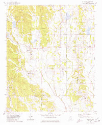
1980 Map of Ellistown
USGS Topo · Published 1981About this map
Birmingham Ridge anchors the eastern side of this northern Mississippi landscape, overlooking a complex network of tributaries such as Tishomingo Creek and Mud Creek. The settlement of Ellistown sits at a historic crossroads near East Union Sch, while the St Louis San Francisco railroad cuts through the southwestern corner near Blue Springs. This 1980s-era survey reveals a deeply rooted rural community defined by its numerous family and community landmarks, including Jones Chapel and McNeil Chapel. The map documents a territory transitioning between the hilly terrain near Bart Hill and the broader bottomlands of Jug Fork. For genealogists, the density of smaller sites like Red Hill Cem and Birmingham Cem provides essential spatial context for local families. The inclusion of field and fence lines, noted as visible from aerial photography, offers a distinct look at the 20th-century agricultural footprint of Union Co and Lee Co.
Find a feature on this map
52 named features on this map. Tap any name to fly to it.
Don’t see what you’re looking for? This feature index may not catch every label — zoom into the map to look around manually.
Map Details
Editions of this 1980 Ellistown Map
This is the sole edition of this map. No revisions or reprints were ever made.
Other maps of this area

1921 · Booneville
USGS Topo · 1:48,000

1921 · Tupelo
USGS Topo · 1:48,000

1922 · Booneville
USGS Topo · 1:62,500

1923 · Tupelo
USGS Topo · 1:62,500

1955 · Ripley
USGS Topo · 1:62,500

1955 · Sherman
USGS Topo · 1:62,500

1956 · Tupelo
USGS Topo · 1:250,000

1958 · Tupelo
USGS Topo · 1:250,000

1973 · Guntown
USGS Topo · 1:24,000
1973 · Tupelo
USGS Topo · 1:24,000