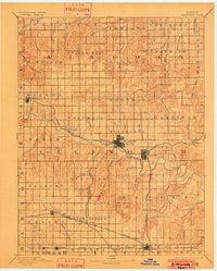
1894 Map of Ellsworth
USGS Topo · Published 1902About this map
The Smoky Hill River carves a central path through this late nineteenth-century landscape, anchoring a network of prairie settlements and emerging rail corridors. The town of Ellsworth serves as the primary hub, where the Union Pacific Railway follows the river valley westward toward Blackwolf and Wilson. To the south, the influence of the Atchison Topeka and Santa Fe Railroad is evident in the development of towns like Holyrood and Lorraine, while the Missouri Pacific Railway skirts the lower boundary near Geneseo. The map reveals a structured grid of townships, including Green Garden, Palacky, and Columbia, which highlight the systematic organization of the Kansas plains. Tributaries such as Wolf Creek and Thompson Creek provide essential drainage across the varied topography, illustrating the relationship between the natural water system and the early agricultural expansion of the region.
Find a feature on this map
67 named features on this map. Tap any name to fly to it.
Don’t see what you’re looking for? This feature index may not catch every label — zoom into the map to look around manually.
Map Details
Editions of this 1894 Ellsworth Map
4 editions found
Other maps of this area

1891 · Great Bend
USGS Topo · 1:125,000

1891 · Hutchinson
USGS Topo · 1:125,000

1892 · Salina
USGS Topo · 1:125,000

1892 · Minneapolis
USGS Topo · 1:125,000

1893 · Great Bend
USGS Topo · 1:125,000

1893 · Hutchinson
USGS Topo · 1:125,000

1894 · Ellsworth
USGS Topo · 1:125,000

1894 · Lyons
USGS Topo · 1:125,000

1894 · Beloit
USGS Topo · 1:125,000

1896 · Osborne
USGS Topo · 1:125,000