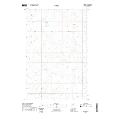
2020 Map of Elm Coulee
USGS Topo · Published 2020About this map
Mona Cem stands as a quiet focal point in this remote section of Richland County, situated near the intersection of Co RD 143 and Co RD 326. The landscape is defined by the complex drainage systems of the Missouri River watershed, where the namesake Elm Coulee and Hay Coulee carve through the high plains. Further north, Steppler Field sits near the headwaters of E Charlie Cr, illustrating the sparse but intentional land use in this ranching country. The map detail highlights the intricate network of section lines and county roads, such as Co RD 139 and Co RD 137, which provide the primary structure for movement across the rolling prairie. Natural watercourses like Middle Charlie Cr and Timber Cr dictate the local topography, creating the draws and ridges that have shaped land ownership and agricultural patterns for generations.
Find a feature on this map
21 named features on this map. Tap any name to fly to it.
Don’t see what you’re looking for? This feature index may not catch every label — zoom into the map to look around manually.
Map Details
Editions of this 2020 Elm Coulee Map
This is the sole edition of this map. No revisions or reprints were ever made.
Other maps of this area

1909 · Glendive
USGS Topo · 1:250,000

1914 · Brockton
USGS Topo · 1:62,500

1954 · Glendive
USGS Topo · 1:250,000

1954 · Wolf Point
USGS Topo · 1:250,000

1957 · Glendive
USGS Topo · 1:250,000

1958 · Wolf Point
USGS Topo · 1:250,000

1958 · Glendive
USGS Topo · 1:250,000
1969 · Twomile Creek
USGS Topo · 1:24,000

1969 · Dugout Creek
USGS Topo · 1:24,000
1972 · Frog Coulee
USGS Topo · 1:24,000