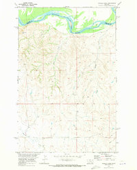
1969 Map of Twomile Creek
USGS Topo · Published 1973About this map
The Missouri River cuts across the northern edge of this landscape, forming the boundary between Richland and Roosevelt counties. Just south of the water, the Fort Peck Indian Reservation Bdy follows a bend in the river, delineating the edge of sovereign tribal land. This 1969 field-checked survey illustrates a sparsely settled region of the Missouri River Basin where human activity is centered on small points like Charlie and isolated Well sites.
Find a feature on this map
11 named features on this map. Tap any name to fly to it.
Don’t see what you’re looking for? This feature index may not catch every label — zoom into the map to look around manually.
Map Details
Editions of this 1969 Twomile Creek Map
2 editions found
Other maps of this area

1909 · Glendive
USGS Topo · 1:250,000

1914 · Brockton
USGS Topo · 1:62,500

1948 · Fort Kipp
USGS Topo · 1:24,000

1949 · Fort Kipp
USGS Topo · 1:24,000

1950 · Calais
USGS Topo · 1:24,000

1954 · Glendive
USGS Topo · 1:250,000

1954 · Wolf Point
USGS Topo · 1:250,000

1957 · Glendive
USGS Topo · 1:250,000

1958 · Wolf Point
USGS Topo · 1:250,000

1958 · Glendive
USGS Topo · 1:250,000