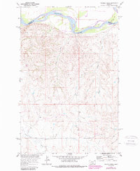
1969 Map of Twomile Creek
USGS Topo · Published 1989About this map
The Fort Peck Indian Reservation dominates the northern landscape of this survey, where the Missouri River creates an indefinite boundary between Roosevelt and Richland Counties. The terrain is defined by a dense network of coulees and drainages including Twomile Creek, Cedar Creek, and Charley Creek, which carve through the high plains toward the river valley. The sharp bend at Devils Elbow highlights the river's dynamic path through this region.
Find a feature on this map
15 named features on this map. Tap any name to fly to it.
Don’t see what you’re looking for? This feature index may not catch every label — zoom into the map to look around manually.
Map Details
Editions of this 1969 Twomile Creek Map
2 editions found
Other maps of this area

1909 · Glendive
USGS Topo · 1:250,000

1914 · Brockton
USGS Topo · 1:62,500

1948 · Fort Kipp
USGS Topo · 1:24,000

1949 · Fort Kipp
USGS Topo · 1:24,000

1950 · Calais
USGS Topo · 1:24,000

1954 · Glendive
USGS Topo · 1:250,000

1954 · Wolf Point
USGS Topo · 1:250,000

1957 · Glendive
USGS Topo · 1:250,000

1958 · Wolf Point
USGS Topo · 1:250,000

1958 · Glendive
USGS Topo · 1:250,000