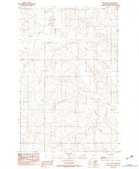
1983 Map of Elm Coulee
USGS Topo · Published 1983About this map
The drainage patterns of the Missouri River plateau define this portion of Richland County as documented in the late 1970s and early 1980s. A network of seasonal waterways, including East Fork Charlie Creek, Middle Fork Charlie Creek, and Hay Creek, carves through the terrain, illustrating the hydrologic character of the eastern Montana plains. The map reveals a landscape primarily dedicated to agriculture and resource extraction, with scattered infrastructure such as Grain Bins, Tanks, and a Gravel Pit positioned throughout the quadrangle.
Find a feature on this map
9 named features on this map. Tap any name to fly to it.
Don’t see what you’re looking for? This feature index may not catch every label — zoom into the map to look around manually.
Map Details
Editions of this 1983 Elm Coulee Map
This is the sole edition of this map. No revisions or reprints were ever made.
Other maps of this area

1909 · Glendive
USGS Topo · 1:250,000

1914 · Brockton
USGS Topo · 1:62,500

1954 · Glendive
USGS Topo · 1:250,000

1954 · Wolf Point
USGS Topo · 1:250,000

1957 · Glendive
USGS Topo · 1:250,000

1958 · Wolf Point
USGS Topo · 1:250,000

1958 · Glendive
USGS Topo · 1:250,000
1969 · Twomile Creek
USGS Topo · 1:24,000

1969 · Dugout Creek
USGS Topo · 1:24,000
1972 · Frog Coulee
USGS Topo · 1:24,000