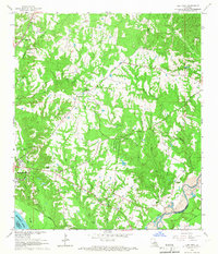
1965 Map of Elm Park
USGS Topo · Published 1966About this map
Rosedown Plantation and Cottage Plantation anchor this mid-1960s survey of the West Feliciana Parish landscape, where the legacies of the plantation era remain etched into the topography. The terrain is defined by a dense network of drainages like Alexander Creek and Grants Bayou that feed toward the Mississippi River. The presence of the Illinois Central railroad and industrial Gravel Pits near Thompson Creek illustrates the mid-century transition from purely agricultural roots to a mixed economy. For genealogists, the map is remarkably detailed, noting specific family-named landmarks such as Locust Grove Cem and Butler Cem, alongside community hubs like the Rosenwald Sch and the Mt Pilgrim Ch. Audubon Memorial State Park serves as a central landmark within this region of deep ravines and complex bayou forks.
Find a feature on this map
40 named features on this map. Tap any name to fly to it.
Don’t see what you’re looking for? This feature index may not catch every label — zoom into the map to look around manually.
Map Details
Editions of this 1965 Elm Park Map
3 editions found
Other maps of this area

1906 · Bayou Sara
USGS Topo · 1:125,000

1939 · St. Francisville
USGS Topo · 1:62,500

1939 · Zachary
USGS Topo · 1:62,500

1941 · Lost Creek
USGS Topo · 1:31,680

1945 · Jackson
USGS Topo · 1:31,680

1945 · Lost Creek
USGS Topo · 1:31,680

1953 · New Roads
USGS Topo · 1:24,000

1954 · Zachary
USGS Topo · 1:24,000

1954 · Port Hudson
USGS Topo · 1:24,000

1954 · Elm Park
USGS Topo · 1:24,000