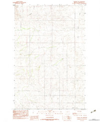
1983 Map of Elmdale NW
USGS Topo · Published 1983About this map
The high plains of eastern Montana are meticulously documented in this provisional study of Richland County. The landscape is defined by the erosion patterns of the northern Missouri Plateau, where Nicholson Coulee cuts through the upland terrain toward the drainage of West Charlie Creek. Compiled from aerial photography taken in the mid-1970s, the map reveals a remote ranching environment marked by section lines and isolated tracks rather than dense settlements. The intricate contour lines illustrate the complex draws and coulees typical of this region, providing a baseline for geologists and local land historians tracking the physical evolution of the township boundaries between T 26 N and T 25 N.
Find a feature on this map
4 named features on this map. Tap any name to fly to it.
Don’t see what you’re looking for? This feature index may not catch every label — zoom into the map to look around manually.
Map Details
Editions of this 1983 Elmdale NW Map
This is the sole edition of this map. No revisions or reprints were ever made.
Other maps of this area

1909 · Glendive
USGS Topo · 1:250,000

1912 · Poplar
USGS Topo · 1:62,500

1914 · Brockton
USGS Topo · 1:62,500

1954 · Glendive
USGS Topo · 1:250,000

1954 · Wolf Point
USGS Topo · 1:250,000

1957 · Glendive
USGS Topo · 1:250,000

1958 · Wolf Point
USGS Topo · 1:250,000

1958 · Glendive
USGS Topo · 1:250,000
1972 · Frog Coulee
USGS Topo · 1:24,000
1972 · Mortarstone Bluff
USGS Topo · 1:24,000